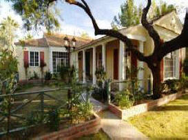
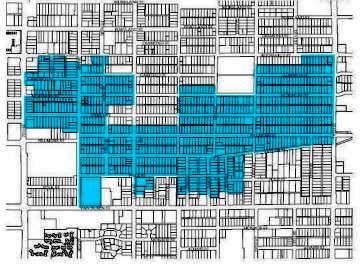
Thanks to the hard work of Garfield residents, its HP Officers, and the Garfield Organization, the Garfield neighborhood has two of the largest historic districts in the city of Phoenix: Garfield and North Garfield. Garfield was developed from 1883 to 1931 and is the oldest historic neighborhood still relatively intact in Phoenix. Garfield was annexed to the original Phoenix Townsite in the 1800's, and most homes in Garfield were constructed from the 1890's to the 1930's. Architectural styles include Craftsman, Classic and California Bungalow styles, Pyramid Cottages, Period Revival, variants of Southwest styles, Prairie-influenced styles, and International.
Garfield Neighborhood is between 7th
and 16th Streets and from Van Buren Street to
Interstate-10 in
downtown Phoenix.
Garfield is where you can still enjoy an
affordable urban lifestyle - without the
commute! We are one of the few neighborhoods in
walking distance to downtown events; whether
your interests are in art, music, sports,
theatre, museums, or politics.
North Garfield: Brill's Addition
Due to its long history, stretching
over the period from outlying ranchland to
central city neighborhood, the North Garfield
Historic District relates to several
developmental contexts for residential
architecture in Phoenix. As one of the city's
first suburban additions, its early growth
relates to the context,
Residential/Architectural Development of
Outlying Areas of Phoenix 1876-1912. Most of its
growth and development occurred in the years
following the completion of Roosevelt Dam (1911)
through the early postwar years ending in 1960.
As a result, its resources can best be
understood in the contexts of the Multiple
Property Listing Historic Residential
Subdivisions and Architecture in Central
Phoenix, 1912-1963, which discusses trends and
patterns of residential subdivisions
(1912-1963), the progression of residential
architectural styles (1912-1963), and the
influence of government housing policies on
Phoenix's domestic architecture and subdivisions
(1934-1963).
Brill's Addition
The origins of the North
Garfield
Historic District can be found in the
irrigation-related development of the Salt River
Valley during the last quarter of the 19th
century. In the early 1880's, German immigrant
Frederick L. Brill bought several ranches on the
outskirts of Phoenix and, as population
increased in the Phoenix area, he platted the
Brill Addition out of his ranch near the
northeastern corner of the city's original
townsite. He was one of many large land owners
who transformed their agricultural property into
residential subdivisions as Phoenix expanded
beyond its original townsite limits.
Brill was one of the areas earliest settlers,
coming to the Arizona Territory in 1865 to
supply beef to the army post at Fort McDowell. A
year later, he established a ranch on the
Hassayampa River about three miles below present
Wickenburg. There he planted the first peach and
apple orchards in the territory. Brill saw that
irrigation was proving successful in the Salt
River Valley and in 1882 he began buying land in
the Valley. Within a few years, he owned three
ranches with 960 acres of irrigated land where
he engaged in general farming and stock raising.
Although he maintained his residence in
Wickenburg, Brill built a fine home on his
property on McDowell Road in 1884. A man of
vision, Brill realized that successful
irrigation in the Phoenix area would bring more
people to the Valley, all of whom would need
housing. Eager to capitalize on the city's
expansion, he platted a quarter section of his
land close to the city limits as the Brill
Addition in 1887.
Brill's Addition is
located between present 7th Street, on the west,
and 12th Street on the east, Roosevelt on the
south, and McDowell Road on the north. He carved
most of the blocks into building lots but left
several large blocks between 11th and 12th
streets undivided. The Dennis Addition, platted
by John T. Dennis in 1883, lay to the south.
These adjacent additions were among the city of
Phoenix's first subdivisions but they saw little
to no growth until the last years of the 19th
century. By 1893, no streets other than Ash
(Roosevelt) in Brill's Addition were depicted in
Sanborn fire insurance maps (Sanborn Fire
Insurance Co., 1893).
Streetcar
Development
Determined to
promote his land, Brill joined with Dennis to
invest in an extension of the Phoenix Street
Railway to provide access to both their
additions in 1895. It was officially designated
the Brill Line for the subdivision it served
(Phoenix City Railway Company map, 1895). The
streetcar ran along Pierce Street to 10th
Street, in the Dennis Addition. There it turned
north along 10th Street, passing through the
Dennis and Brill additions to its terminus at
McDowell Road. That same year, Brill amended his
plat to conform to the city's grid (Amended Plat
of Brill's Addition, 1895). He configured his
blocks along 10th Street so that their lots
fronted directly onto the streetcar line. Long
blocks between 7th and 9th streets were divided
so that most of the lots fronted onto the named
streets (Roosevelt Street, Portland Street,
Moreland Street, etc.), while a row of lots
fronting onto 7th Street, a major north-south
arterial. It is apparent from his plat that
Brill understood the importance of direct
transportation.
Still, only a few houses
were built between the extension of streetcar
line and 1911, when Roosevelt Dam was completed
(Sanborn Fire Insurance Co., 1901, 1911). Only
four extant houses appear to pre-date the dam
construction in the district. One substantial
resource is the George Hidden House (Listed in
the National Register in January 1995). The
house was built in 1896 and features Victorian
detailing (763 E. Moreland Street). Although
George Hidden was the original owner, E. W.
Akers, a librarian, owned it for many years. Two
houses built ca. 1900 (1131 E. Moreland Street)
and ca. 1902 (724 E. Portland Street) are
vernacular houses with little or no stylistic
embellishment. The fourth, a ca. 1905 dwelling
(1101 N. 10th Street) features Classical Revival
ornamentation. H. J. Plummer, an auctioneer, was
an early resident of the house in 1918 but the
original resident/owner is unknown. There may
have been other houses built during this period
but they are no longer extant. After 25 years,
very little development had occurred in Brill's
Addition.
About 1909, Brill began selling
parts of his undivided blocks between 11th and
12th streets to individuals who resubdivided
them for development. The subdivided parcels
typically ranged from about three to six acres;
some consisted of only three or four lots. Among
the more noteworthy were Diamond Heights (1909),
bounded by Roosevelt on the south, Portland on
the north, and 11th and 12th streets. The
subdivision included both sides of a new street
in the district, Diamond Place. Another early
subdivision was Douglas Place (1909) which
consisted of the north side of E. Moreland
Street between 11th and 12th streets. Several
other new subdivisions (Vista, Mountain View,
and La Grande) were carved from blocks in the
northern part of Brill's Addition by 1910. These
lie outside the boundaries of the North Garfield
Historic District.
All of these new
subdivisions were configured so that the lots
faced east-west streets. Notably, the La Grande
and Vista subdivisions rearranged Brill's
original orientation, possibly to obtain more
building lots. Later subdivisions in the
addition tended to follow suit. In virtually all
cases, resubdivision resulted in more building
lots. For instance, Stoner's Subdivision (1912)
turned two and a half lots into eight small
ones. Likewise, Reser's subdivision (1920) cut
two lots into five.
The proliferation of
subdivisions by 1909 indicated that development
was imminent in the neighborhood and in 1910 the
city of Phoenix annexed all of Brill's Addition
into the city limits.
Roosevelt
Dam and Subsequent Development
The 1911 Sanborn Fire Insurance maps show
Brill's street and block configuration but did
not detail any individual properties within the
addition. The addition probably had a few
scattered dwellings but their small numbers did
not warrant full documentation by the company.
That would change dramatically within a few
years. The completion of Roosevelt Dam in 1911
improved mans ability to control the waters of
the Salt River and establish more comprehensive
and reliable irrigation for farming. The event
promised an agricultural bonanza for the Valley
and the impact on Phoenix's population and
development was immediate and intense. Hundreds
of new families moved to the Valley; some moved
to the new suburban additions to be closer to
their irrigated fields. Still others made their
living selling groceries, supplies, and
contracting services to the new families. They,
too, built houses in the new subdivisions which
were close to the city center and accessible by
streetcar line.
By 1915, four years after
the dam's completion, Sanborn maps show about
180 new houses in Brill's Addition, 101 of which
lay in the southern streets of the addition
which are now included in the present North
Garfield Historic District. Virtually all of the
houses built between 1912 and 1915 were the
then-popular Classical Revival and Craftsman
bungalows which filled the 700-1100 blocks of
Roosevelt, Portland, Moreland, and the 1000-1200
blocks of 9th and 10th streets in the district.
City directories and other sources indicate that
more houses were built by the end of 1915.
Within the North Garfield segment of Brill's
Addition, approximately 29 new houses were built
in 1915 alone.
Following great activity
between 1912 and 1915, development in the
district slowed a bit, possibly due to domestic
building restrictions related to World War I.
While 29 new houses were completed in 1915, only
two were built in 1916 and one in 1917, at the
height of the war. Residential growth rebounded
in 1918 when 21 new houses were built. Only one
house has been dated to 1919 in this survey. In
all, at least 55 single family homes built in
the North Garfield Historic District between
1912 and 1919 survive to the present. Again,
these were largely Craftsman influenced
bungalows in the western half of the present
North Garfield Historic District.
Post-World War I Development
War restrictions were lifted and
development started anew in the district by
1920. In that year alone, at least 39 single
family houses and duplexes were built in North
Garfield. Although more were undoubtedly built,
at least 84 resources in the North Garfield
Historic District survive from the period
1920-1929. The great majority, including the
duplex, were Craftsman inspired bungalows. Some
displayed no discernable style. The Pieri-Elliot
House at 767 E. Moreland, is a rare Prairie
School style dwelling in the district. Designed
by A. J. Knapp and built in 1922, the house is
listed in the Phoenix Historic Property Register
and was listed in the National Register of
Historic Places in December 1983. One of the
neighborhood's first court's appeared at
1116-1118 E. Portland in the 1920's; it consisted
of several identical apartments designed in the
Southwest Style. Such courts would later become
more common in both the Garfield and North
Garfield Historic Districts. Other new property
types in the district include the ca. 1925
1-part Commercial building at 1151 E. Moreland
Street, which served as a neighborhood store,
and a Mission Revival style church at 1013 N.
13th Street.
During the post-World War I
building boom, much of the original Brill's
Addition was built to completion and development
necessarily began moving toward the eastern half
of the present North Garfield Historic District.
Until 1920, residential development in the area
was almost entirely limited to the western
portion of the district, in the southern half of
Brill's Addition, possibly due to reliance on
the streetcar which passed through the district
along 10th Street. By 1920, however, automobiles
were becoming more common and streetcar
transportation no longer dictated where you
lived.
In the early 1920's, as Phoenix's
population grew, the eastern section of the
district opened to intensive development when
large blocks were re-subdivided for individual
housing lots and new subdivisions were platted
beyond 12th Street to the east. Some of the
plats contained only a handful of lots. One of
the first of the postwar additions was Albright
Subdivision, which was a re-plat of lots 11 and
12 of the original Brill's Addition Block 12. It
contained only five lots; four fronted onto
Moreland Street and the last fronted onto 11th
Street. The following year, property owners in
Block 9 of Brill's Addition re-platted their
tracts to form seven residential lots, six of
which fronted onto Moreland Street. One of the
larger projects at that time involved the owners
of Block 19 of Brill's Addition who platted the
block into 32 lots (A Subdivision of Block 19
Brill Addition, 1920). They established eight
lots each fronting onto Moreland Street,
Portland Street, 11th Street and 12th Street.
With the exception of Block 19, most of the
new plats were laid out with their lots fronting
onto the east-west streets of Moreland Street,
Portland Street, Diamond Street, and Roosevelt
Street. The Belvedere Amended plat, filed in
1920, carved the 1200 block of Moreland into 24
lots, all fronting onto the east-west street
(Belvedere Amended, 1920). The 1922 Sasse
Addition extended eastward from Brill's
Addition. It established 24 lots on both sides
of Moreland between 14th and 15th Streets.
Another 12 lots were set along Belleview, to the
north (now part of Interstate 10).
The
Belvedere addition, in particular, experienced
sustained development in the early 1920's.
Between 1920 and 1925, 18 houses were built in
the 1200-1300 blocks of E. Moreland Street, east
of Brill's Addition. Their proximity to one
another, their close completion dates, and the
fact that they all follow the Craftsman style,
indicates that it was a planned development on a
scale rarely seen in the area to that date.
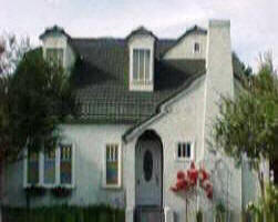
In the latter years of the 1920's, Craftsman
houses remained popular but Period Revival
styles ascended in the neighborhood. In 1928, a
Spanish Colonial Revival house was built at 1406
E. Moreland Street. Others followed in the early
1930's when Tudor Revival, Southwest, and English
Cottage styles began to outnumber the formerly
dominant Craftsman styles. Another style that
emerged in the neighborhood beginning in 1930
was the Early Ranch.
The neighborhood was
eclectic in its mix of residents. A snapshot of
the demographic composition in 1929 shows a
number of salesmen such as E. H. Swant (1023 N.
11th Street) and D. E. Welch (1106 N. 14th
Street), clerks including A. G. Alvarado (1317
E. Diamond Street), and accountants such as H.
F. Nelson (1005 E. Moreland Street). Some were
occupied in building trades such as plumber Leo
Francis (1109 E. Diamond Street). A number of
mechanics, including auto mechanic H. B.
Grevillius (726 E. Portland, rear) and W. N.
Ryker (1334 E. Roosevelt Street) lived in the
district. Jack Reid was the grocer for the store
at 1151 E. Moreland. Few professionals lived in
the neighborhood but several public servants
including police officer B. E. Smith (1116 E.
Diamond Street) and the Deputy County Treasurer,
Anna Hertz (1131 E. Moreland Street) made their
homes in the district. Overall, the neighborhood
appeared to be a mix of predominantly Anglo
middle- and working-class families.
Development Continues in the Great
Depression
By the 1930's, the
western half of the North Garfield Historic
District was filled with single family houses,
the majority of which exhibited Craftsman
influenced ornament. With the exception of the
1300 block of Moreland, however, whole blocks in
the eastern half of the district lay
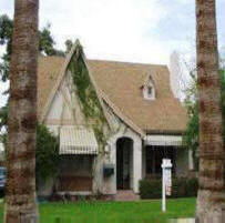
undeveloped. In the early 1930's, Early Ranch,
Southwest Style, Spanish Colonial Revival, Tudor
Revival and
English Cottage style houses began
to appear in the 1300-1400 blocks of Diamond
Street, Portland Street, and Moreland Street.
Only 16 houses were built in the district
between 1930 and 1934 and, while it is lower
than earlier construction rates, it was probably
more successful than other areas of the city
during the Depression.
Beginning in the
mid-1930's, home buyers were offered federally
insured loans that guaranteed mortgages to
lenders. The Federal Housing Administration
(FHA) loans provided the necessary leverage for
many home buyers to afford to build houses
during the Depression. While there was a marked
slowdown in house construction from 1931-1934,
beginning in 1935, the district saw resurgence
in home building. Eight new houses, sporting a
variety of designs from Craftsman, Early Ranch,
and Southwest and
Spanish Colonial Revival
styles were built primarily on Moreland Street
and Diamond Street in 1935.
One of the
great success stories of the depression occurred
in La Tourette Place, in the eastern part of the
Garfield district. Platted in 1931, the subdivision was
stymied by the poor economy and lay undeveloped
for the next seven years. By the mid 1930's,
however, federally insured loans through the
Federal Housing Administration (FHA) were made
available to qualified home buyers, opening a
new market for residential construction.
These loans provided the necessary insurance to
encourage builders to construct homes on a
speculative basis in the latter years of the
Great Depression. It was in this context that
contractor Wright Davis and the A. B. Angle
Lumber Company combined their efforts to build
homes in the 1400-1500 blocks of Diamond Street
in La Tourette Place. Between 1838 and 1940,
Wright oversaw the completion of 34 homes in the
1400-1500 blocks of
Diamond Street. All but one
of the houses used FHA financing. Ultimately, 44
homes were completed in the 1400 and 1500 blocks
of Diamond Street.
FHA loans may have
been responsible for much of the other
construction that took place in the eastern half
of the North Garfield district, as well. Between
1938 and 1942, at least 66 new single family
homes were built in North Garfield, primarily in
the easternmost blocks of Moreland Street,
Portland Street, and Diamond Street. However, La
Tourette Place is the only significant area of
the
North Garfield Historic District that was
promoted and developed under the federal
mortgage insurance program. This represents a
major building effort during the Great
Depression and the first years of World War II.
By 1939, the country had suffered a decade
of financial depression. Nevertheless, city
directories showed that many families in the
North Garfield Historic District managed to keep
their homes. A random sampling of 34 addresses
showed that about 40% of occupants throughout
the district owned their own homes. They
included A. L. Nesbit, manager of Arizona Dental
(1022 N. 10th Street), C. N. Burlingham, a clerk
for a power company (1109 N. 13th Street), E. L.
Springer, a furrier (1122 N. 13th Place), J. B.
Everett of Home Service Laundry (1414 E. Diamond
Street), and salesman G. H. Blackford (1425 E.
Portland Street).
Again, a variety of
occupations were represented in the district.
Many were in building trades or clerical
positions. Plumber F. E. Castle (724 E. Portland
Street) and cement plasterer David Hamilton
(1429 E. Diamond Street) owned their own homes.
Numerous bookkeepers (A. C. Long at 1018 N. 9th
Street), accountants (J. H. Fraker at 1030 N.
9th Street), and clerks, including E. A. Hill
(1118 N. 12th Street), who worked for the Works
Progress Administration (WPA), lived in the
district. As in 1929, few professionals lived in
the district but a number of teachers and
ministers resided there. Among them were Rev. R.
B. Scott (1017 N. 13th Street), pastor of the
Garfield Methodist Church and teachers J. M.
Smelser, who owned his home at 1410 E. Moreland
Street, and Lynnie Lackey (715 E. Portland
Street).
Post World War II
Development
In the postwar
period, many new subdivisions opened in the
Phoenix area but numerous vacancies remained in
the North Garfield Historic District. Close to
the downtown area, many people continued to
build in the district, particularly in the
eastern portion that had not been entirely
finished by the outbreak of the war. As was true
throughout Phoenix and, indeed, much of the
country the Ranch Style dominated new
construction design in the postwar period. In
North Garfield, Ranch variations included Early
or Transitional Ranch, French Provincial, and,
simply, Ranch styles. An International Style
duplex and a Southwest Style house were built in
1945, but the great majority of houses built in
the area between 1945 and 1955 displayed some
type of Ranch Style attributes.
By 1955,
the
Garfield neighborhood was largely built out and many
homes were owner-occupied. Of a random sampling
of 47 addresses, nearly 60% (28) were
owner-occupied. The district remained eclectic
but solidly middle- and working-class in its
demographics. Many building contractors and
mechanics lived in the district as did clerks,
accountants, teachers and nurses. More single
women were heads of household including Harriet
Kosinski, a hospital aide who owned her duplex
at 1114 N. 10th Street, Roberta Brogdon, a
pianist and piano teacher who owned her house at
1441 E.
Diamond Street,
Anna Marty who owned her duplex at 1119 E.
Moreland Street, and Flora Gossard who owned her
house at 1109 E. Diamond Street. The district
remained largely Anglo, though some Hispanic
surnames could be found in city directories.
Although some single family houses were
built in the 1960's, 1970's and 1980's, a number of
lots were developed or redeveloped as apartment
buildings. By 2000, a new wave of single family
construction occurred in the neighborhood. Some
of the older houses were torn down and replaced
with new houses, many of which adopted bungalow
characteristics in size and style. Numerous
side-gabled bungalows with shed-roofed dormers
were built in the neighborhood, especially on
Moreland Street, between 2000 and 2008.
More disruptive to
the neighborhood than scattered new construction
and redevelopment was the construction of
Interstate 10 through the northern part of the
Brill Addition and adjacent subdivisions.
Planned and laid out in the mid-1950's, and
revised in 1960, the freeway was hotly
contested, more for its gargantuan design than
for its destruction of hundreds of buildings in
its path. In the North Garfield area additions,
the freeway construction that took place over
several decades eradicated entire blocks north
of Moreland Street disrupting the building
fabric and tranquility of the remaining
neighborhood. Today, a noise-dampening concrete
wall defines the northern edge of North
Garfield, separating the neighborhood from the
massive interstate highway.
Architectural History
Although
Brill’s Addition was platted in 1887 and the
streetcar line came through the addition by
1895, only one house in the
North Garfield
Historic District appears to date from the late
19th century. Built in 1896, the house at 763 E.
Moreland Street is an example of late Victorian
design, of which very few are still standing in
Phoenix. Notably, the house was built the year
after the streetcar line was established along
10th Street, only a few blocks away. A few other
houses in the neighborhood date from about 1900
to about 1905. The ca. 1900 house at 1131 E.
Moreland Street is another Victorian style house
with a projecting ell and bay window. Houses
from this period were either on the streetcar
line or only a few blocks from it.
The
completion of Roosevelt Dam in 1911 incited
growth throughout In the Valley but several
years passed before the building boom reached
the North Garfield Historic District. A few
pyramidal roofed cottages with half-façade inset
porches supported by Classical order columns
were built in the district about 1912. An
example is the house at 1027 N. 9th Street,
which has an overarching pyramidal roof, a
hipped dormer, and half-façade inset porch
supported by square Doric columns.
By 1915,
however, Phoenix's growth finally spread to
Brill's Addition. Sanborn Fire Insurance maps
show numerous houses in the blocks of Portland
and Moreland closest to the streetcar line along
10th. Tenth Street received significant growth,
as did 9th Street, one block away. A time of
tremendous growth, the district filled with
Craftsman-influenced bungalows, a style that
gained widespread popularity throughout the
country. Most bungalows were rectangular in plan
and featured two adjacent rows of rooms, one
relegated for private use (bedrooms, bathrooms),
and the other for public use (living room,
dining room, kitchen). Hallmarks of the
Craftsman bungalow are exposed structural
members such as rafter ends, purlins, and knee
braces. Porches were typically supported by
tapered wood posts set on brick piers.
The bungalow enjoyed a long period of favor with
the American people and that is clearly
reflected in the North Garfield Historic
District. Of 116 extant buildings constructed in
the
North Garfield Historic District between
1915 and 1925, 98 exhibit predominantly
Craftsman characteristics. Of the remaining
number, 15 have no particular style, one house
can be classified as Prairie Style, and one is a
Southwest style residential court. The final
property from that time period is a commercial
building. These figures show the overwhelming
popularity of the
Craftsman bungalow
in
North Garfield
during its first period of substantial
growth. Good examples include the house at 1026
N. 10th Street, 1022 N. 9th Street, 1005 E.
Moreland Street, 1033 E. Moreland Street, and
720-722 E. Portland Street.
The bungalow
remained popular through the 1920's though other
styles made inroads in the district. By the last
years of the 1920's,
Period Revivals including
Spanish and Tudor Revival styles gained favor.
In 1926, a Mission Revival church was built at
1013 N. 13th Street. Small Southwest style
apartment courts appeared in the district. Among
them are those at 1132-1134 E. Portland Street
and 1136-1138 E. Portland Street. Construction
in the district continued throughout the Great
Depression, particularly in the eastern section.
Widespread automobile use reduced the necessity
for building on or near the streetcar line and
new houses, many with garages, began to appear
in the 1400-1500 blocks of E. Moreland Street,
E. Portland Street, and E. Diamond Street.
Period Revivals remained in vogue but Early
Ranch style houses began appearing in the
eastern half of the district.
Between
1938 and 1942, a major housing development
occurred on
Diamond Street, aided by government backed
mortgages made possible by the Federal Housing
Administration (FHA). This section of the North
Garfield
Historic District possesses a wide
variety of residential architectural styles from
the period. Although Southwest, Spanish
Colonial, and
Tudor Revival houses were built in
the 1400-1500 blocks of E. Diamond Street,
Early
Ranch homes and
French Provincial Ranch houses
appeared, as well. Several International Style
and Moderne houses were also built in the
district.
After World War II, different
varieties of Ranch Style houses filled in the
gaps throughout the district which was almost
completely built up by 1955. By the mid-1960's,
parts of the district suffered redevelopment
with apartment complexes replacing single family
houses, particularly in older parts of the
neighborhood. More recently, new bungalows
have replaced older ones in the district,
especially on Moreland Street.